Water Shortage: Myth or Reality? Underground aquifer
ABSTRACT: An analytical article devoted to the study of the freshwater aquifer. Water is the "white coal" of planet Earth and is the primary source of human life. From this article, you will learn: - About the underground water reserves. - Whether to be afraid of the quick disappearance of water. - The experience of the union of irrigation scheme experts. - About underground fresh water oceans, which total water supply outweighs the volume of the oceans of the world by several times. - Information about the huge underground ocean under the Sahara Desert.
Water is a unique substance of our planet, which has no equivalents in the whole world. We cannot imagine our existence without it. The average human body consists of 70% water and water covers 71% of the Earth's surface. Did you know, the bowels and the core of the Earth, have a water reserve; which contains 10 times more water, than on the surface? About one-third of the world's surface, water storage is fresh and suitable for human consumption, the remaining two parts sea waters that are not used for agriculture or drinking, and the rest is the water in the glaciers.
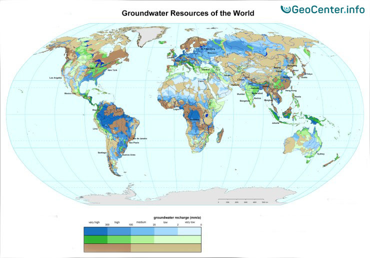
The annual value of the renewable underground water resources countrywide ranges from hundreds and even thousands of cubic kilometers to its tenths and hundredths parts. Six large countries that are rich in renewable water resources include; Brazil, Russia, Canada, the USA, China, and India.
In this article, we are going to review the problems of water shortage. Is the life-giving source running low or is someone stopping experts from solving the problem, in order to delay water supply to regions that desperately need it?
With the help of a powerful lever of influence, such as the mass media, the information on water shortage is being spread. Let’s not deny the fact that someday this raw material will run out, as they say. Nevertheless, let's see whether this information is true, or is it just another "lie" that was made in order to push the people to continue to live in a competitive climate of a consumer society, and not in unity and harmony with Nature's wise self-sufficiency.
A modern human has a great mental potential for development. With the help of truthful scientists out there, whose joint efforts will solve the issue of water supply in such dry regions as India and Africa.
In 1953, the British geologists discovered the Nubian aquifer, while searching for oil deposits in the Sahara desert. Fresh water was hidden under a layer of hard brownstone (like a lens) with a thickness of 100 to 500 meters. As established by scientists, water accumulated underground at a time when fertile savannas stretched in the Sahara and were irrigated with frequent abundant rains.
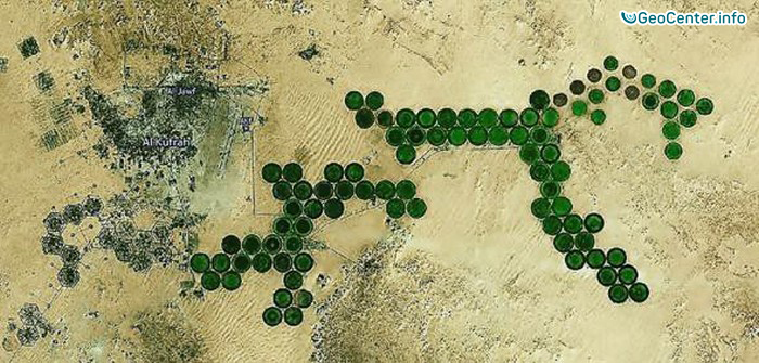
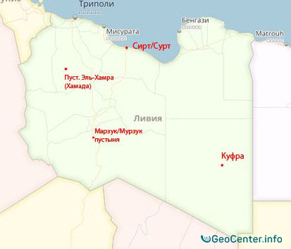
The Nubian Sandstone Aquifer System (NSAS) is the world's largest known source of fossil freshwater. It is in the eastern part of the Sahara Desert and spans the boundaries of four countries in north-eastern Africa. NSAS covers an area of just over 2,000,000 km2, including the north-western Sudan, the north-eastern part of Chad, the south-eastern Libya, and much of Egypt. It contains about 150,000 km3 of groundwater. This system is mainly used to supply water to the Kufra oasis.
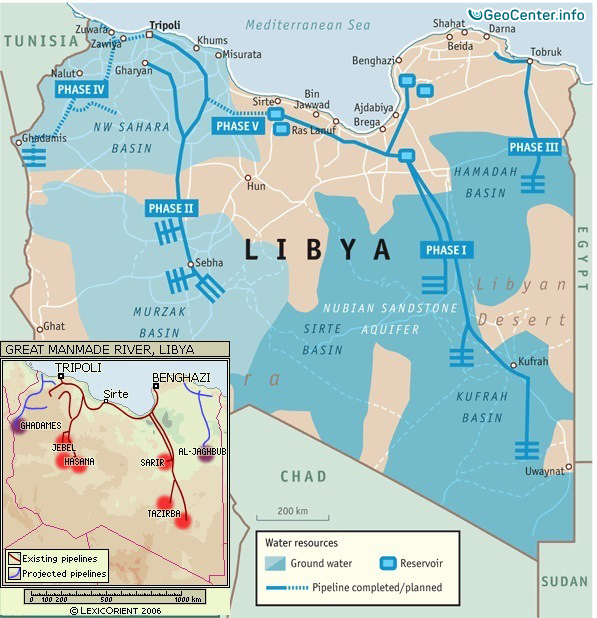
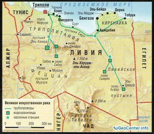
At one point in time, the Libyan territory had riverbeds that flowed into the Mediterranean Sea. Those beds dried up many years ago, but scientists managed to find huge underground reserves at a depth of 500 meters. Some reservoirs have been formed relatively recently - about 5000 BC. They make up the largest portion of all the sources in the country, leaving 2.3% for surface water and 1% for desalinated water.
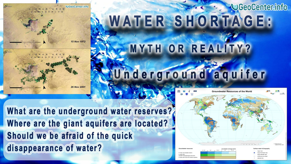
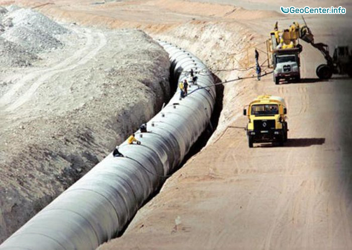
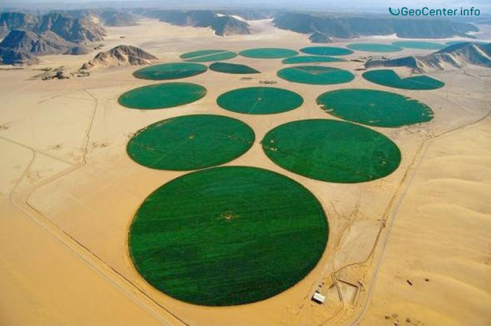
Then in the 60s, an idea arose to construct an irrigation system, with work beginning in 1983. The project included 4,000 km of pipes that are buried deep into the ground away from the heat. The underground water was drawn through 270 mines, located hundreds of meters in depth. More than 1,300 wells were formed, with depths ranging from 1 to 3 km, from which water was delivered to the surface and distributed to major channels. The diameter of the circular fields, on top of which water sprinklers rotated, ranged from several hundred meters to 3 km.
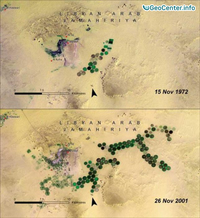
The space view on the fields, from December 26, 2016:
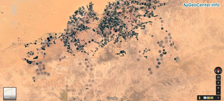
This project was named the "Eighth Wonder of the World" and entered the Guinness Book of Records due to the scale of the construction. The main task was to ensure the flow of 6,500,000 m3 of water per day along the desert and increase the area of irrigated lands. Now, the project is stopped for an indefinite period.
For reference: before the construction of the Great Man-Made River (GMR) had started, 96% of the Libyan territory was accounted for as a desert, and only 4% of the land was suitable for a human living. After the full completion of the project, 155,000 hectares of land was supposed to be supplied with water. At least one full working source of water would be enough to provide the entire southern part of the African continent with water. Given the fact that in African countries there is great concern about fresh water. Just imagine, if the scientist were to combined their skills, the continent could have fields of wheat and other resources necessary to support life.
“With all existing current technologies, it is real to turn the Sahara into a blooming garden and supply its fruits to a considerable part of humanity. Not to mention the abundance of fertile soils on the Earth that is more than sufficient to make such notion as hunger, no longer exist on this planet.”
A quote from the book “Sensei of Shambala. Book IV” by Anastasia Novykh.
In 1960, four huge underground water reservoirs were discovered in Libya in the Sahara desert are: the Kufra basin, the Sirt basin, the Morzuk basin, and the Hamada basin.
India is an example of a country where water is polluted in almost all sources. The local rivers, Indus and Ganges, are polluted with arsenic ( a chemical that is toxic) and salts. Experts say the groundwater supply is insufficient in that area. The need of constructing channels, that will deliver part of the water from the large rivers is always discussed. Still, the project of the giant channel Telugu Ganga already exists, which should address the problem of water supply in large cities with rapidly developing industry in southern India.
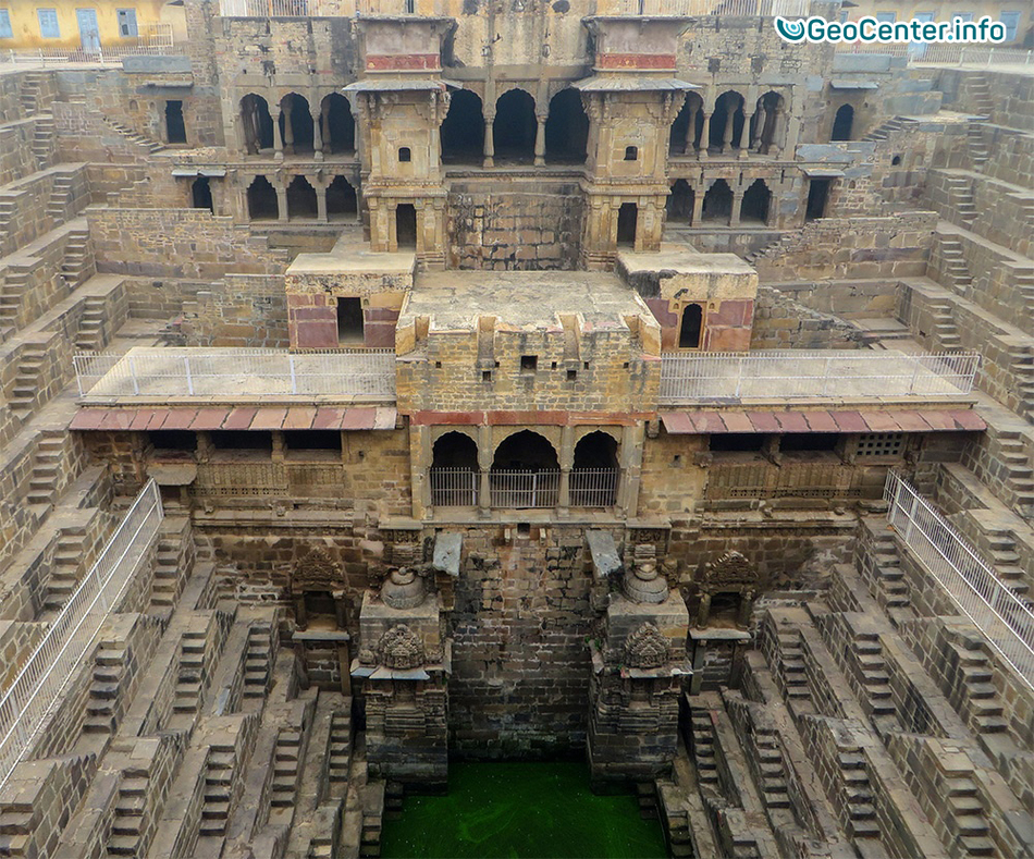
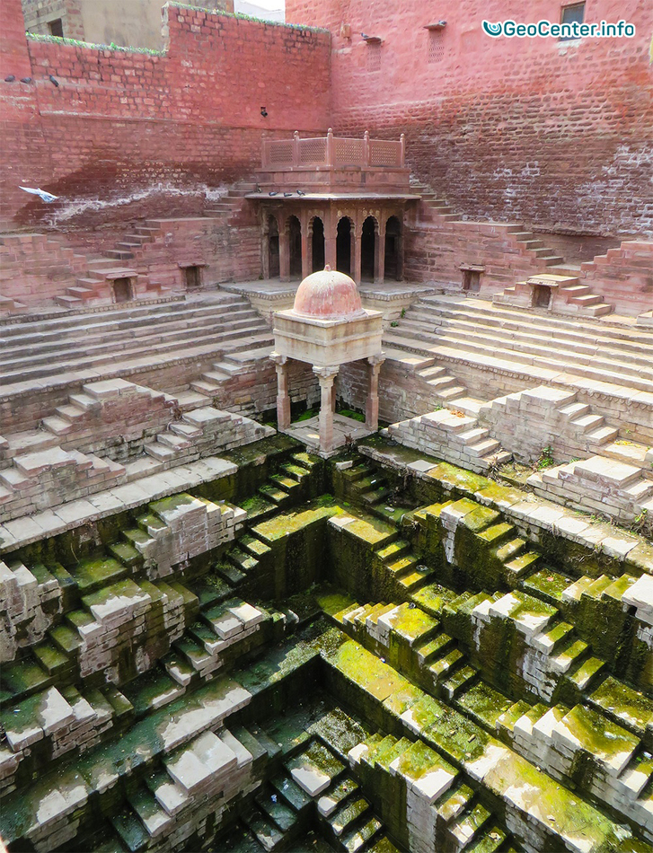
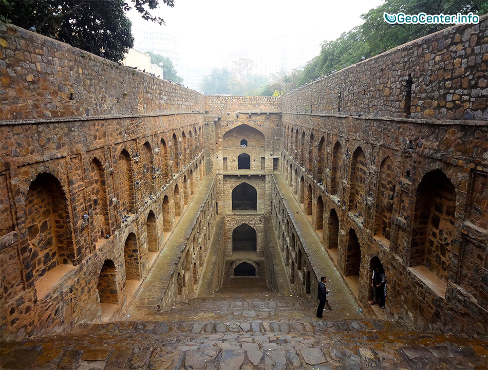
Returning to the experience of previous civilizations, people then did not have materials and technical resources possessed by the modern society, yet could solve problems concerning water shortage. On the territory of India, located many slowly decaying, amazing, architectural structures. These included, stone wells that are 30 meters deep. In the 1980s, a journalist Victoria Lautman captured these massive structures designed to access the groundwater and collect rainwater in the regions where dry months are replaced by weeks of torrential spring monsoons.
Thousands of wells were built in India between the II and IV centuries A.D. as natural ditches, which gradually evolved into a much more complex achievement of engineering and art.
Let us recall, the main part of the country’s water resources is a flow of rivers, which are formed by precipitation during the monsoon season (June to September). Since the 1950s, a large-scale hydro technical construction has been organized in the country. Large and medium-sized dams were constructed, which regulate the flow to and from reservoirs in the main river basins of the country.
Even after the construction of these dams, the issue of water shortage is not solved. For example, the annual water consumption level per capita in India is only 213 m3. As in comparison to Russia- 6,103 m3/year, Australia - 4,733 m3/year, the US - 1,964 m3/year, and China - 1,111 m3/year.
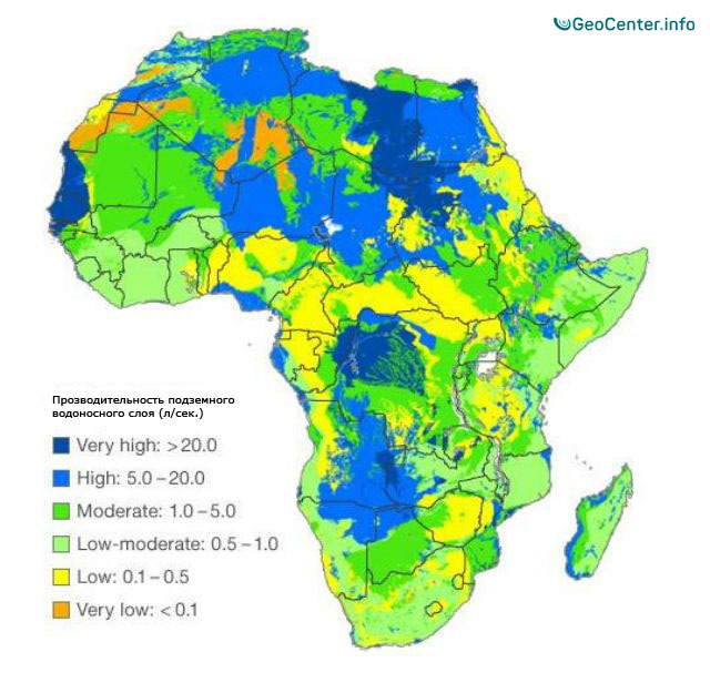
In southern Asia, about 60 artesian basins of fresh water were discovered, characterized by low capacity. They are supplied by the flow of rivers that run from the mountains and the flow of temporary streams and precipitation. Thus, in dry areas, deserts and semi-deserts, rivers supply underground waters, including artesian ones.
Summing up the results for India, we give some optimistic estimates: according to the calculations by the "Groundwater Resources Assessment Group", the fresh water reserves in India exceed the official records by 66%, and according to different sources- by 88%.
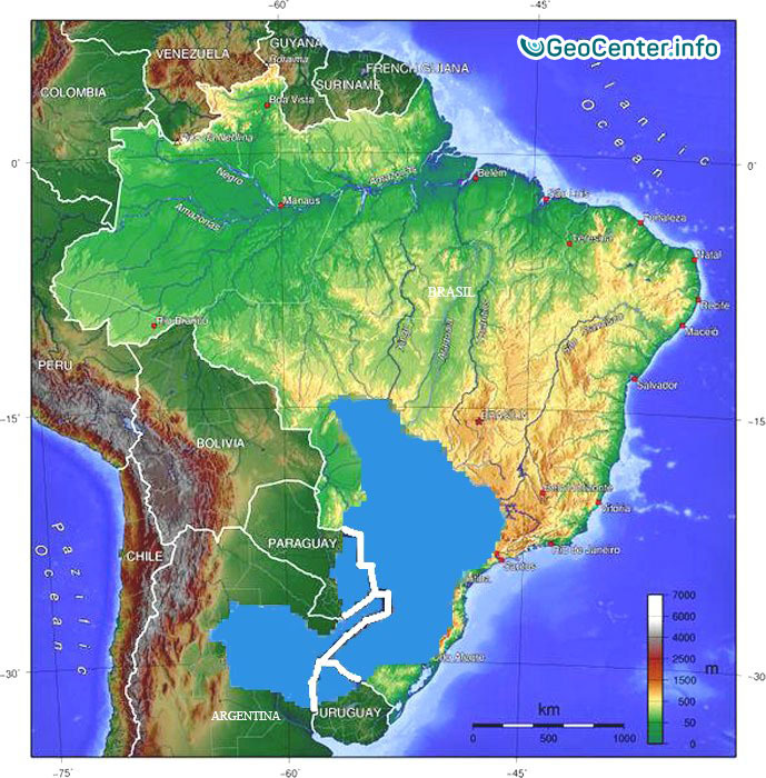
In Brazil, the Amazon river has a twin, the underground river Hamza. The underground river runs at a depth of about 4,000 meters through the porous soil parallel to the Amazon river. It measures about 6,000 km long and about 400 km wide and empties into to the Atlantic Ocean, deep under the surface. According to preliminary data, Hamza river has a high salt content. The evidence of the underground river were presented at the 12th International Congress of the Brazilian Geographical Society in 2011 and have not been published anywhere else since then. Scientists have explained that the research results are preliminary and that more detailed scientific validation is to be expected in the coming years. To address the problem of water "shortage", one can turn to the experts involved in desalination of sea and salt water. A giant Guarani Aquifer is also located on the continent. It serves as a storage of a renewable groundwater, which provides Argentina, Brazil, Paraguay, and Uruguay with water.
A group of international geochemists discovered an ocean of the Archean period (2.7 billion years old) under the Earth’s surface in Canada. It is located at a depth of 410-660 km, and its volume exceeds the World Ocean by 3 times. The water is sealed in a crystal structure of a mineral “Ringwoodite”. This is a translucent mineral of a gray-blue color from the olivine group. It is formed at an extreme temperature of 1530 °C and under a pressure from the minerals wadsleyite and ferrite forsterite. It is approximately located between the core and the earth’s crust, in a layer of the lower mantle at a depth of 520-660 km. Scientists came to this conclusion by researching solidified samples of a lava flow.
A team of scientists from the Chinese Academy of Sciences, conducted research in the Tarim Basin, located on the western edge of the country. This area is extremely dry without any flowing rivers. The scientists drew attention to the level of carbon-dioxide absorbed by the forests and seas, which occurs in large quantities. This fact has confounded the scientists. Moreover, one of the world’s largest sand deserts is located here. It is named the Taklamakan Desert, which is over 1,000 km long and up to 400 km wide, with the sand area of more than 300,000 km².
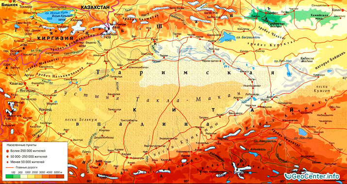
The Tarim Basin is surrounded by a mountain range, from which rivers and snow drain into the desert. Usually, water is straining through the sand as a filter and then it evaporates, but in the Tarim Basin, it accumulates at a depth of several thousand meters. Numerous samples drawn across the desert have shown that the ocean is everywhere under the desert.
The approximate scientists’ results state that the Tarim Basin contains ten times more water volume then the Great Lakes - the largest group of freshwater lakes on the Earth, which is about a trillion tons. The underground reservoir in China is salty too. However, with a help of modern technologies, it is possible to desalinate the water and use it for agricultural needs.
Chinese researchers state that the American Mojave Desert is an active carbon absorber, and therefore a huge body of water may be hiding in its depth. Perhaps deserts, along with forests and oceans, are another natural filters and reserves of environmental resources.
In addition, a large underground water reserves are also located underneath the World Ocean, which can be divided into two types of geological structures: the mobile area is a home for crack waters, waters of rift basins of hydrogeological structures used for unconsolidated sediments, and the stable hydrogeological area characterized by silt waters are also located in unconsolidated sediments overlying a crystalline basement..
In the 70s, the Soviet scientists drilled the well-known Kola Superdeep Borehole, which measured 12 km in depth. It was subsequently abandoned as an unpromising borehole, and work on it to this day has not been restarted, resulting in its gradual destruction. The US scientists have cut a hole into the depth of the earth to a depth of 9 km, but scrapped the idea of getting to the core and the Earth's upper mantle as well.
However, there are other methods of diagnosing the Earth's interior layer. One of them is with the use of seismographs. The most seismically active points of the planet are covered with sensors of seismographs like a spider web. In the San Andreas Fault, due to wells, sensors are injected into the friction joints of tectonic plates. A comprehensive analysis of the results of such testing, allowed a group of scientists, led by a Professor Michael Waysession of Seismology Department at Washington University, concluded that in the Earth’s upper mantle, under the eastern part of the Eurasian continent, at a depth of about 1,000 km, located a huge water reservoir, which is comparable to the Arctic Ocean by volume.
By studying and analyzing the measurement data accumulated by various groups of geoscientists for the past 30 years, the experts from the University of Oregon, whose group was headed by Anna Kelbert, had created a three-dimensional map of the distribution of electrical conductivity of the upper layers of the Earth's mantle. The map confirms the presence of large amounts of water in it. However, that water is not free but is in a bound state, which is a part of the crystal lattices of different minerals.
Top 10 world's largest aquifers:
Brazil (8,233 km³); Russia (4,508 km³); the United States (3,069 km³); Canada (2,902 km³); China (2,840 km³); Colombia (2,132 km³); Indonesia (2,019 km³); Peru (1,913 km³); India (1,911 km³); Venezuela (1,320 km³)/Republic of the Congo (1283 km3).
Note that we have considered land only, which occupies 1/3 of the Earth's surface. Current studies show that there are underground oceans underneath the existing oceans, which exceed them by many times in volume. Therefore, the total reserve of underground aquifers is very significant. The science of the future will be able to solve the global problem of drinking water shortage.
In summary, the set of the above-mentioned facts shows that the problem of water shortage is not as drastic as perceived today. With a common goal, scientists all over the world can unite and resolve existing water shortage problems. Thus, people who were concerned about survival due to water shortage will be able to take a deep breath and redirect their attention towards the development of themselves and society in cultural, moral, and spiritual aspects. It will save not only material resources but, above all, time. Time is a nonrenewable resource, which should be used effectively for individual’s spiritual development.
The Unity of people is the foundation for the survival of humanity!
Prepared by Ekaterina Ageychenko and Vitaliy Afanasiev
GeoCenter.info
![]()